"AROUND THE WORLD WITH Dr.DoDIDDILY AND THE DEE DOT'S"
WHICH IS BASED FOR PROTECTION INSIDE
THE DRAGON LORDS CASTLE
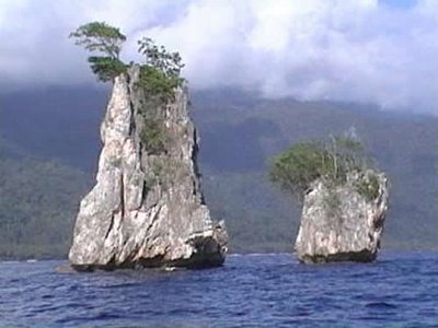
THE SPICE ISLANDS
Today the "Spice Islands" are known as Maluku (or The Molucca Islands).
A Schools Curriculum Project which follows the journey of Tim
Severin as he retraces the steps of the famous explorer Alfred
Russel Wallace in the Spice
Islands of Indonesia. This project is coordinated by the University
of Limerick, Ireland and has received financial funding from the Department
of Education in Dublin and Bord na Gaeilge.
(WHICH WAS LAST UPDATED IN JUNE 1996)
THIS IS THE KAI ISLANDS - By Pulau Kei Kecil
Kai Islands
Island group in Indonesia
The Kai Islands of Indonesia are in the south-eastern part of the Maluku Islands, in Maluku Province.
Halmahera, Seram, Buru, Ambon, Ternate, Tidore, Aru Islands, Kai Islands
These are main Spice Islands
Today the importance of the Spice Islands is as one of the few
surviving areas of primary tropical rainforest with a rich natural
history. In previous centuries the islands' importance lay with
their name. As the source of cloves and nutmeg they were the focus
of attention from traders since 300 B.C. or possibly earlier.
Chinese, Indian and Arab merchants sought out these riches long
before the European powers came to Maluku. The Arab connection,
in particular, meant that the Muslim Influence was very strong.
Individual sultans amassed great wealth and came to control the
precious spice trade. Indeed, by the early 1500s, Maluku was known
as Jazirat-al-Muluk or "Land of Many Kings."
It was at this time that Europeans first came to the Moluccas
in search of cloves and nutmeg. They were highly valued as food
preservatives. Wealthy ladies used to keep spices in lockets around
their necks so they could freshen their breaths easily. Gentlemen
added nutmeg to food and drink. Spices were also used for medicinal
purposes, especially in the relief of colic, gout and rheumatism.
Such great demand meant that the prices of nutmeg and cloves soared.
To offset this crisis expeditions were launched to find the source
of these spices and bring them directly back to Europe.
Christopher Columbus was searching for the fabled route to the
Indies when he arrived at the Americas in 1492. Not long after
this the Portuguese enforced their rule on parts of the Moluccan
Islands. Along with the spice traders came military forces and
missionaries keen on converting the natives of the islands. Conflict
soon broke out and the Portuguese brutally crushed the islanders.
The natives continued to disrupt Portuguese trade and everyday
life in the islands and within a century they were replaced by
the Spanish. They did not last long either and lost out to the
Dutch who governed the islands between 1605 and 1945.
The period of Dutch rule is marked by the usage of vast plantations
as a means of producing vast quantities of spices for the European
markets. All the land was under the control of the Dutch East
Indies Company and anyone caught selling land, however small,
was executed. By the early 1800s new plantations of spices in
Africa and India meant that there was a greater choice of supply
available to the traders. As a consequence, prices fell and the
Dutch were in trouble. It was around this time that Alfred Russel
Wallace arrived in the Malay Archipelago.
Today, the Spice Islands make up Maluku Propinsi (or Maluku Province)
of the Republic of Indonesia.
Spice Islands (Moluccas): 250 Years of Maps (1521–1760)
The Indonesian archipelago of the Moluccas (or Maluku
Islands), commonly referred to as the Spice Islands, lies on the
equator north of Australia and west of New Guinea. Though there are
hundreds of islands in the group (most are very small), only a handful
figure prominently in the history of the European spice trade,
including today’s Ternate, Tidore, Moti, Makian, and Bacan—essentially
the ones shown on the surrounding maps. Until the 1700s, these
rain-forested, luxuriant, volcanic islands were the only or best
sources of such spices as cloves, nutmeg, and mace.
Arab traders introduced cloves to Europeans around the
fourth century but sought to keep their sources secret. Their monopoly
was broken by the Portuguese after Vasco da Gama’s voyage to India
around the Cape of Good Hope in 1497. The Portuguese strengthened their
stranglehold on the spice trade during the sixteenth century, when
they found the central locus of the spices to be these islands. One of
the native traditions was to plant a clove tree when a child was born,
linking the child symbolically to the life of the tree. When the Dutch
took over control of the Moluccas in the seventeenth century, they
eradicated the clove trees from all the islands except Amboina (and a
few adjacent islands) in order to enforce the spice’s scarcity, keeping
prices high. As a result, cloves were worth more than their weight in
gold. But, as one might expect, the Dutch tactic also instilled hatred
and fomented rebellion among the islanders. Gradually, the spice was
cultivated in other places of the world, like Brazil, the West Indies,
and Zanzibar, reducing prices and making the commodity more available.
However, the historical significance of these islands
cannot be overstated. Largely because of the magnetic force of spices,
European ships risked sailing into unknown waters (Portuguese ventures
down and around Africa), “found” a New World (Columbus’s crossing of
the
Atlantic), and first circled the globe (Magellan’s crossing of the
Pacific).
TANIMBAR ISLANDS
Tanimbar Islands located in southeast of Moluccass Islands, the biggest
islands province in Indonesia. Due to the its remotedness, not many
people ever visit or even heard about this islands and its culture. One
traditional culture that almost extinct in Tanimbar is Tnabar Dance.
Tnabar dance is more than just a showcase, it's an ancient Tanimbar
people tradition to communicate with their ancestors, so the ancestors
can preserve them. The Tnabar dance divided into two kinds of dance,
Tnabar Ila'a (all performed by men) and Tnabar Fanewa (all performed by
women). The uniqueness of Tnabar dance is the dance only can performed
by a big number of people (at least 25-30 people), and there are several
role in the dance.
The formation in Tnabar dance resembled a snake,
since they believed all the Tanimbar people came from a snake. The dance
basically is a song, sing by a song leader (called Kual Ralan),
followed by some movement played by the rest of group. There are three
song sing during the dance, and to start the song a dancer called Farai
always perform a warcry lyric with a movement resembled an eagle. After
the Farai the Kual Ralan will sing the song, while the Tiwal Ralan (four
people inside the half circle played the Tifa, traditional Moluccans
percussion) played the Tifa, and the others dancer make a slight
movement. The dancer in the circle that have bigger part to move is the
Ulu Kual (the first dancer in the line). This Tnabar Fanewa dancer
is performed by Wadankou girls, played in Nurkat Village, Molu Maru
District, in the National Education Day Celebration held in Nurkat.
Wadankou, the remotest village in Tanimbar Islands, known as their well
preserved tradition such as this dance, cakalele dance, Foruk (ancient
poem tradition), Dobol (another upbeat dance from Tanimbar), and so on.
The Spice Island - BURU - Island in Indonesia
Buru
is the third largest island within Maluku Islands of Indonesia. It lies
between the Banda Sea to the south and Seram Sea to the north, west of
Ambon and Seram islands
The island was first mentioned around 1365. Between 1658 and 1942, it
was colonized by the Dutch East India Company and then by the Crown of
the Netherlands. The Dutch administration relocated many local villages
to the newly built island capital at Kayeli Bay for working at clove
plantations. It also promoted the hierarchy among the indigenous people
with selected loyal rajas placed above the heads of the local clans.
The
island was occupied by the Japanese forces between 1942 and 1945 and in
1950 became part of independent Indonesia. During former President
Suharto’s New Order administration in the 1960s–1970s, Buru was the site
of a prison used to hold thousands of political prisoners.
Fun for all the children of the world with Dr. Dodiddily and the Dee Dot's
A little bit about myself and my Sisters
Kath, (far left) Sylvia, blonde (middle) Dorothy (me far right) Amy (Toni, in front)
Dr. Dodiddily is one of four sisters. First there is my sister Sylvia, she is the eldest and the smallest. Then there is my sister Toni(Amy)
she is two years younger than Sylvia, Toni lives in Kent. The next
one born in 1944 was Dorothy, yes my lovelies this is my real name. I am
three years younger than Toni. One more to come and that is my sister
Kathleen, she is the baby of the family and she is four years younger
then myself.
We couldn never hand our cloths down to each other, we were all very
different sizes, and anyone coming after me wouldn't have been able to
wear anything I was such a tom-boy and thing were worn out long
before Kath could have them.
This is a very old picture of the four of us taken in Coed Poeth in North
Wales, way back in 1952/3. Gosh I am an Ancient Dragon, aren't I ! xxx.
This
is myself and my sisters in 1979 just 26 years later, we are with our
mother who like myself was called Dorothy. We are from left to right
Sylvia, Toni, My Mum, Dorothy (me) Kathleen.
Jayden, Noah Rhys, Brody Leigh with Diddily in the background you can just see my grey hair.
Summer 2014 in the back garden at my home in Pontybodkin another 35 years later.
WE CAN'T HAVE THE SPICE ISLANDS WITHOUT SPICE ISLAND FOOD... TAKE A LOOK AT THIS
India had spent the previous two millennia spreading its culture to the Spice Islands of the east.
THE SPICE ISLANDS
1521: Pigafetta, Antonio,
ca. 1480/91–ca. 1534. “Figure of the Five Islands Where Grow the
Cloves, and of Their Tree.” From volume 2 of Magellan’s Voyage: A Narrative Account of the First Circumnavigation.
Translated and edited by R. A. Skelton (New Haven, Conn., 1969). Shown
with the permission of the Beinecke Rare Book & Manuscript
Library. [Rare Books Division]
On that day of Sunday I went ashore to see how the cloves
grow. The tree is tall and as thick as a man. Its branches in the
center spread out widely, but at the top they grow into a kind of peak.
The leaf is like that of a laurel, and the bark of the color of brown
tan. The cloves come at the tip of branches, ten or twenty together.
These trees almost always bear more of them on one side than on the
other, according to the season. When the cloves sprout, they are white;
when ripe, red; and when dried, black. They gather them twice a year,
at Christmas and again on the feast of St John the Baptist, because at
these two seasons the air is most temperate, but more so at Christmas.
And when the year is hotter, and there is less rain, they gather three
or four hundred bahar* of cloves in each of those islands, and they
grow only in the mountains. . . . Nowhere in the world do good cloves
grow except on five mountains of those five islands. . . . We saw
almost every day a cloud descend and encircle first one of those
mountains and then the other, whereby the cloves become more perfect.
(1:120–21)
*A bahar is a unit of weight approximating 400 pounds.
This
wonderful map and information belongs to the
http://libweb5.princeton.edu/visual_materials/maps/websites/pacific/spice-islands/spice-islands-maps.html
where you can find many more journey's made my the explorers during the
early years of sea travel.


")

